NASA study shows link between Deepwater Horizon spill and coastal wetlands erosion
‘Dramatic, widespread shoreline loss …’
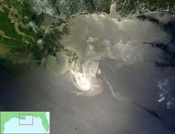 |
| A NASA satellite image shows the oil slick from the Deepwater Horizon disaster spreading across the northern Gulf of Mexico in late May, 2010. |
Oil washed toward shore after the 2010 Deepwater Horizon disaster is a big factor in coastal erosion rates, according to scientists with NASA and the U.S. Geologicial Survey who tracked the changes along the Gulf of Mexico. Their research shows a pattern of dramatic, widespread shoreline loss” along the Louisiana’s coast in Barataria Bay, located on the western side of the Mississippi River Delta.
The study compared images of the shoreline taken a year before the oil spill with images taken during a 2.5 year span after the spill. Scientists also compared shoreline losses from storm-induced erosion with losses linked to shoreline oiling. Storm-induced erosion occurred at isolated shoreline sections, but the pre-spill shoreline from 2009 to 2010 was largely stable.
But, in the first year after the spill, from 2010 to 2011, the images showed widespread erosion throughout the bay, with the biggest shoreline losses in areas documented with heavy to moderate oiling. Two years after the spill, the higher erosion rates also affected areas that were less oiled. Some of the shorelines studied received treatment to reverse or stop environmental damage from the spill, but researchers found no measurable difference in their erosion compared to non-treated shorelines.
“Our study uniquely shows the patterns of shoreline recession seen in Barataria Bay are directly relatable to distinctly different causes,” said Amina Rangoonwala, USGS geophysicist and lead author of the study. “There was broadly dispersed erosion due to oiling from the Deepwater Horizon spill and more severe, but localized, erosion from Hurricane Isaac.”
The wetland impacts of the spill documented by the team included both shoreline erosion and wetland fragmentation, a process where small islands are broken into even smaller islands. Land lost in fragmented areas is unlikely to be reestablished because there are no new sediments flowing in to replenish what’s lost to erosion. This creates a higher possibility that natural coastal defenses against flooding will be reduced.
The images used for the study came from NASA’s Uninhabited Aerial Vehicle Synthetic Aperture Radar, developed and managed by NASA’s Jet Propulsion Laboratory. The system operates from a C-20A research aircraft and its polarized radar produced detailed representations of the marsh, which USGS scientists then used to develop a process to analyze the shoreline recession and its causes.
“Through this process, USGS and NASA scientists developed a repeatable, quantitative mapping method that will allow us to monitor shoreline erosion after oil spills in the future,” said study co-author Cathleen Jones of JPL.

Comentários
Postar um comentário